
DRONES-G MINI
Lightweight drone module with integrated radiation detector
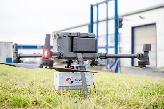
After a radiation incident, or when an orphan source is suspected, the area must be mapped quickly without sending personnel into the hazardous zone. DRONES-G MINI moves this survey onto an unmanned aerial vehicle: it measures the gamma spectrum and dose rate and transmits the data to the ground station in real time. The system weighs 1.125 kg including the holder and covers dose rates from 50 nGy/h to 20 mGy/h.
Key features
- Wide dose rate range: a NaI(Tl) scintillation detector and an energy-compensated GM tube cover 50 nGy/h to 20 mGy/h.
- Radionuclide identification in flight: a gamma spectrum every second, 50 keV to 3 MeV, resolution FWHM < 7.5 % at 662 keV.
- Independent of the carrier: own power supply, positioning and radio link; the unit is attached to the carrier mechanically only.
- Comparable values at any flight height: the laser altimeter (0–50 m) converts the dose rate to 1 m above ground in real time.
- Data on the ground during the flight: 433 MHz radio link with a range of up to 3 km line of sight, plus simultaneous recording to a microSD card.
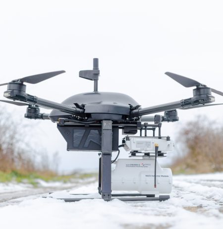
- Designed for light UAVs: 1.125 kg including the DJI M300 RTK holder, up to 1.5 h of operation per charge.
- Wide operating temperature range: operating temperature −30 °C to +55 °C.
System overview
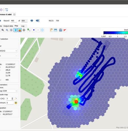
Both detectors, the multichannel analyser (MCA), GPS module, laser altimeter, temperature, pressure and humidity sensor, battery and radio module are housed in a single enclosed body. Every record carries time and position and is stored on the memory card in PEI format. The ground station consists of a Windows tablet or laptop, the DRONIC software and a radio module connected via USB. DRONIC displays the spectrum waterfall and a map of the measured quantity on OpenStreetMap, identifies radionuclides and calculates the minimum detectable activity (MDA). PEIDataViewer software exports data to ASCII/CSV, Geosoft, ANSI N42.42 and KML/KMZ for Google Earth; NuSOFT ProView is optionally available for post-processing. The system can be mounted on any carrier with sufficient payload capacity and endurance; a carbon-composite holder is available for the DJI M300 RTK.
Typical applications
- Emergency services rapidly map a smaller affected area after an incident without sending personnel into it.
- Radiation protection staff search for orphan sources using the spectrum and the dose rate map during the flight.
- Security forces verify a suspected source at a specific location from a safe distance.
- Site operators repeatedly survey the same route and compare data converted to 1 m above ground.
Main parameters
| Parameter | Value |
| Detection | |
| Spectrometric detector | NaI(Tl) Ø 1″ × 2″, MCA with 256, 512 or 1024 channels |
| Energy range | 50 keV – 3 MeV |
| Energy resolution | FWHM < 7.5 % at 662 keV (¹³⁷Cs) |
| Dose rate range – NaI(Tl) | 50 nGy/h – 80 µGy/h |
| High dose rate detector | energy-compensated GM tube LND 71210, 50 nGy/h – 20 mGy/h |
| Maximum count rate | 50 kcps (with dead-time correction) |
| Positioning and data transmission | |
| Positioning | A-GPS, GLONASS / Galileo |
| Laser altimeter | 0-50 m |
| Radio link | 433 MHz, up to 3 km line of sight |
| Data recording | microSD 8 or 16 GB, PEI format |
| Power supply and design | |
| Battery | Li-Po 11.1 V / 500 mAh, up to 1.5 h of operation |
| Dimensions (L × W × H) | 272 × 114 × 108 mm (without antenna) |
| Weight | 1.125 kg (including DJI M300 RTK holder) |
| Operating conditions | |
| Operating temperature | −30 °C to +55 °C |
| Relative humidity | max. 80 % |
Dose rate refers to air kerma rate.
-
1.125 Kg
Weight
-
2 detectors
GM tube and NaI(TI)
-
1.5 hours
Battery life
Need help?
If you have an enquiry about any of our products or services, please do not hesitate to give us your feedback or suggestions.